
$8,600.00
Olex Seafloor Mapping & Plotting System
Olex Seafloor Mapping & Plotting System
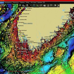
Olex calculates a sea floor map using data from GPS and echosounder. For each new measured depth, the map improves. The survey takes place automatically and requires no operation. The sea floor map can display in 2D with contour lines or relief, and in 3D with a virtual camera which can be used to look around the seafloor. Bottom zoom is used to highlight selected depth areas. In addition comes special functions like calculation of water and bottom mass volume, and tools for searching and removal of bad measuring’s.
The system works under UNIX, for the time being Linux. All software is manufactured by Olex AS, except the tide calculations which are handled by XTide2 The system runs with electronic vectorized charts. Effective use of digital charts requires fast computer processing. The chart cells are converted into an internal compact format, where they are kept in different crude scaling levels. By continuously recording depth and position the system builds a database where the sea floor is divided into squares of any resolution. The default resolution is 5X5 meter, an adjustment of today’s GPS equipment, but the user can easily create new sea floor databases in any resolution down to a few cm. New measurements will result in a recalculation of the unmeasured squares in some radius from the considered point.
Included:
1-MMS 12V Rugged Nav PC w/ 20′ Power Cable
1-Olex Plotting & Seabed Mapping Software License
1- S63 Style Chart Of Your Choice
1-Choice of 17″ Or 22″ Display (Mount included) w/20′ Power cable
1-GPS Premade 20′ Data Cable
1-Sounder Premade 20′ Data Cable
1- 10′ HDMI or VGA Cable
1- Olex Remote or MULTI TRACK BOX
1- Wireless Trackball
1-Wireless Keyboard
3 Year Warranty On MMS NAV PC’s